5.19.2006

The end of paper maps

The Times predicts the end of paper maps:

[GPS is] gradually killing off maps, the charts that have revealed the changing contours of our world and minds since the birth of culture. English mapmakers once placed the phrase Hic sunt dracones, “Here be dragons”, on maps to mark the edges of the known world. Charlene [the GPS] has slain what few dragons remained. With a GPS embedded in dashboard, wristwatch or mobile telephone, we will never be lost again.
Apart from the fact that cartographers never actually did put "here be dragons" on maps, I don't think our London correspondent is right. There's no way that paper maps will disappear. Did the horse disappear with the invention of the automobile? No, it exists alongside the car, although certainly its purpose changed.

The paper map is just too darned useful; it's light, needs no electricity, and is interoperable across systems and cultures. How many times have you printed out a digital map? I rest my case.

5.18.2006

A Perfect combo

A perfect combo of map and politics is achieved in the following map. Only 3 states in America give the President a positive job approval rating:


Source: Billmon, data here

5.16.2006

The Politics of Geography

The latest (5/15/06) opinion polls for President Bush in Georgia show an interesting geographical split between the Atlanta metro area and rural Georgia. But even outside the metro area his unfavorable ratings are high. Georgia as a whole is 43% approve, 55% disapprove.


South and East Georgia


Metro Atlanta


All Georgia

5.11.2006

Crashing the Gate, Atlanta!


Crashing the Gate came to Atlanta on Tuesday. Markos of Daily Kos was there and talked a bit about the new political landscape of netroot activism before taking some Q&A. It's podcasted here by the Georgia podcast network. The turnout, in Atlanta's famous Manuel's Tavern, was fantastic! I've only got low-res cellphone pictures, but here they are:


Getting ready


Markos and founder of Air America(?)


My attempt at a crowd scene...

5.08.2006

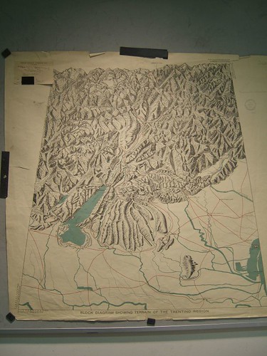
Beautiful block diagrams


Block diagrams are out of favor today, but at one time they were a useful and evocative way of representing terrain. One of the acknowledged experts in this field was Armin Lobeck (1886 - 1958). It's a shame that Lobeck's work is not better known (though his book things Maps Don't tell us is still in print and features a selection of his diagrams). As far as I know the only biographical work on him is a Masters thesis by Fred Grandinetti.

During WWI Lobeck was employed by the US government in their preparations for peace and he made a number of detailed studies of the areas likely to be discussed.

Here are some images of these maps (available at the National Archives, College Park, MD).

5.04.2006

"The Internet is our Edgar R. Murrow. It's all we have."

That comment was made in response to a story on Eric Boehlert's new book Lapdogs: How the Press Rolled Over for Bush which documents the way the press is not doing it's job anymore: critically investigating the spin emanating from the White House. In fact, the book suggests (not for the first time) that the press's complicity in the "Swift Boat" attacks on Kerry lost him the election and all that that entails.

Colbert's amazing routine at the annual White House Correspondents' Association dinner last Saturday is another example, and if it has been under-reported by the "MSM" this week, it's probably because of zingers like this one:

But, listen, let's review the rules. Here's how it works: the president makes decisions. He's the decider. The press secretary announces those decisions, and you people of the press type those decisions down. Make, announce, type. Just put 'em through a spell check and go home. Get to know your family again. Make love to your wife. Write that novel you got kicking around in your head. You know, the one about the intrepid Washington reporter with the courage to stand up to the administration. You know -- fiction!
Journos = typists.

So it's no surprise that people turn to the internet to get other news. Things like google.news.com or the BBC Online and as I've said before investigative blogging (Juan Cole, Atrios, TPMuckraker, etc.).

In this context then the recent moves to threaten "net neutrality" are extremely dangerous. If content is to be differentially moved across the internet because telcos and cable companies want people to pay them based on that content [not format] then we're hosed. I know threats to the internet have been around almost as long as... well the internet itself, but read here and make up your own mind. It's worth noting that the inventor of the web, Tim Berners-Lee, is on record preferring content neutrality.

We should know by now that knowledge is not separate from power.

5.01.2006

More Recent Sprawl Analyses

Since the NLCD data in the study cited below are a little old as Brian mentions below (not that that invalidates the data of course, particularly for time series analysis), here are some references to more recent studies:

Yang, Xiaojun "Satellite Monitoring of Urban Spatial Growth in the Atlanta Metropolitan Area" Photogrammetric Engineering and Remote Sensing, 2002, 68(7). Uses data from 1973-1999 (Thematic Mapper/Landsat).

Yang, X. and Lo, C.P. "Modelling Urban Growth and Landscape Changes in the Atlanta Metropolitan Area" Int. J. Geog. Inf. Sci. 17(5): 463-488.

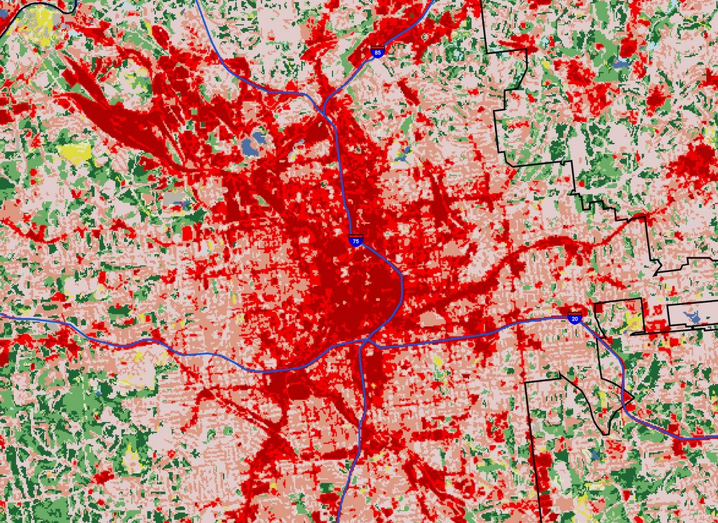
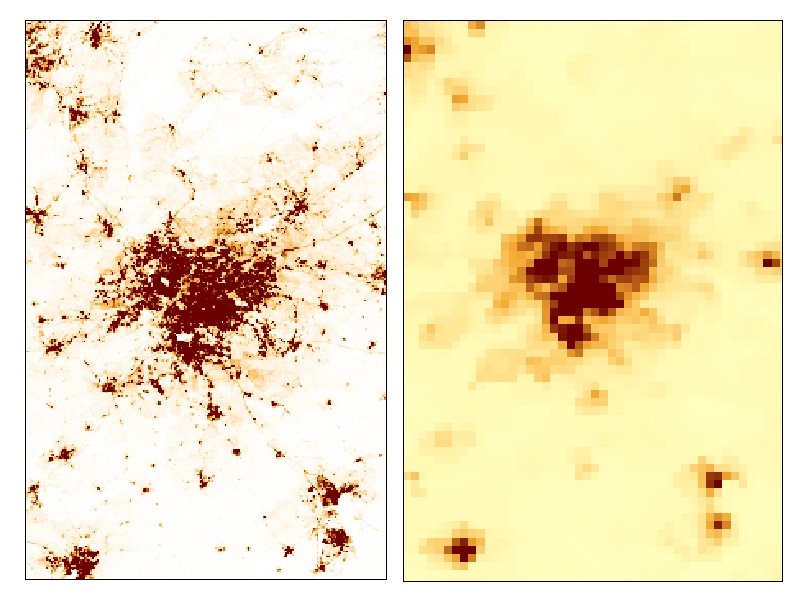
Finally, newer NLCD data actually are becoming available here (2002). Comparison of NLCD and Landscan data:


NLCD 2001 on left, Landscan on right. Approx. same scale but not exactly (and on diff. projections I believe).

Detail of downtown Atlanta. Red indicates urban areas I believe. City of Atlanta boundary shown in black. Original resolution is 30m square.

Atlanta May 1 Rally

Pictures from the rally today in Atlanta.


4.29.2006

Satellite Imagery of Sprawl

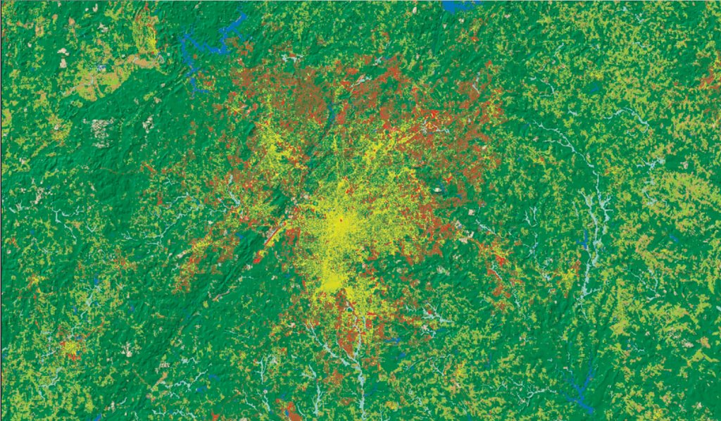
Coincidentally to my posts on population densities in the Southeast and in Atlanta, a new study has been announced using satellite imagery to measure urban sprawl:


Atlanta urban area, yellow = 1976, red = 1992)

The data are appreciably out of date unfortunately, especially for rapidly growing areas such as Atlanta, but still nevertheless provide an interesting perspective. The authors created a nationwide set of 30 square meter cells from the USGS National Land Cover data (mentioned below).

It should be easy enough to georeference this data even without the original files. There's also an interesting nationwide poster done on the Albers Equal Area projection with a nice shaded relief background.

Here is the actual paper.

(h/t to Cartography).

FBI Secretly Spied on 3,501 US Citizens in 2005

The AP reported today that the government secretly issued National Security Letters on 3,501 US citizens and legal residents to look at their bank, credit card, telephone and Internet companies in 2005.

Last year 9,254 NSLs were issued against 3,501 people but we don't know how many were issued in previous years. We only know this number because of reporting requirements in the Patriot Act, although there are possibly thousands of other letters unreported. I wrote about this last December, when the Washington Post revealed the fact that these letters are highly secret (no legal oversight) and if you get one you can't mention it to anyone else and of course seek legal advice:

The FBI security letters have been the subject of legal battles in two federal courts because, until the Patriot Act changes, recipients were barred from telling anyone about them.
Ann Beeson, the associate legal counsel for the American Civil Liberties Union, said the report to Congress "confirms our fear all along that National Security Letters are being used to get the records of thousands of innocent Americans without court approval."
So far only two organizations have challenged NSLs, both represented by the ACLU. Basically these are secret subpoenas sent to organizations for information about their clients or customers.

4.27.2006

Landscan and urban areas

(Updated below)


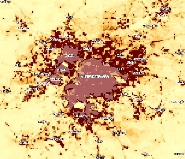
Here is a comparison of Landscan (again just pop count, needs to be corrected for pop density) and official "urban areas."

Obviously it matches up quite well but we'd need to see next how these urban areas were defined. The City of Atlanta, by the way, would be an even smaller area in the middle (I didn't include it for clarity but will put on a later posting).

Update: here it is:

More on Landscan

I said yesterday that Landscan and CIESIN incorporate additional (ancillary) population estimates. In many cases census data are too coarse a resolution (blocks in the US) or out of date. What data does Landscan incorporate?

Their most recent data is for 2004. It includes some high-resolution land cover data from the National Geospatial Intelligence Agency (NGA), administrative boundaries, and some satellite imagery I'm not familiar with (anyone? what is NGA's VMAP-1 or CIB), plus some actual imagery from the space shuttle on topography (SRTM) which is pretty cool. For more see here.

Other data include roads (TIGER in the US); slope angle (the Digital Terrain elevation [DTED] from the NGA predecessor, NIMA); land cover imagery in this case USGS Global Land Cover Characteristics (GLCC)--again I'm not familiar with this, if anybody has any info please leave in comments--is it any good, are there any better ones for the SE USA?

Also populated places (the VMAP data); nighttime lights; and census data being allocated to cells by a so-called "smart" interpolation routine (if roads are in the cell, allocate more population?).

Resolution is apparently 30" by 30" or about 1 square kilometer, hence much better than CIESIN which is 2.5' at best.

Now I need to know how to apply the density grid. There's no documentation on the Landscan site and emails to their office go unanswered.

4.26.2006

Characterizing Places with GIS

I plan to start a series of posts that attempt to characterize the US southeast and Atlanta in particular using GIS.

There are a number of reasons to do this, partly because I want to see how easy or difficult it is to do with GIS and what insights it affords.

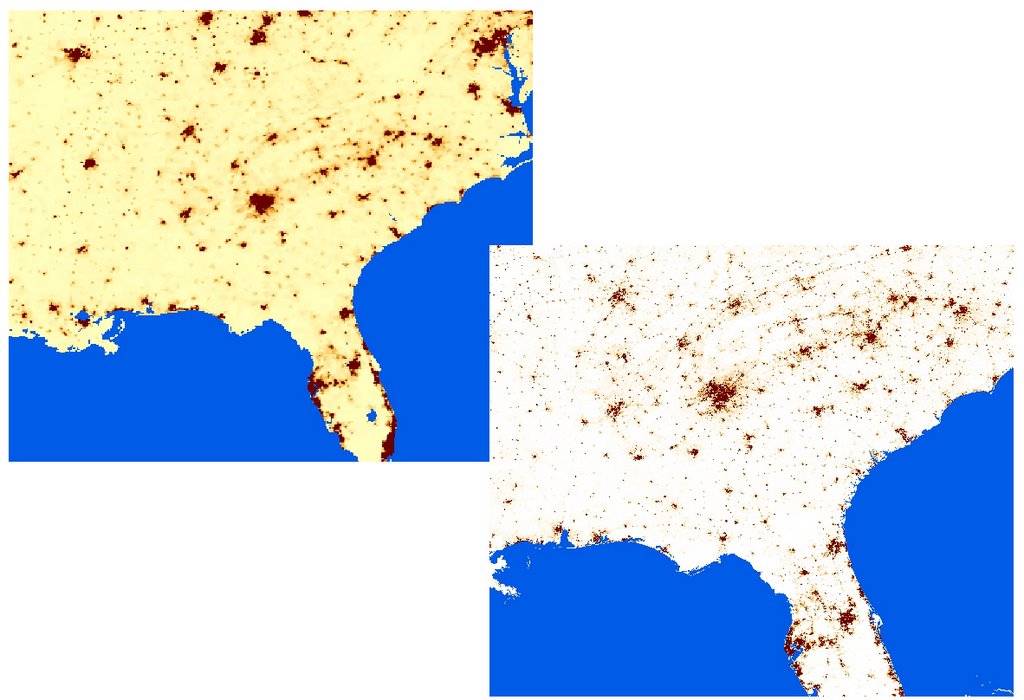
Obviously Census Bureau data will be very important, either from 2000 or updates via ACS. I've never used ACS so that is another reason to become more familiar with it. First up though, two non-census sources for population: Landscan (bottom right) and CIESIN (top left).


Both use supplemental data (lights at night etc.) to provide estimates of population. CIESIN data are at 2.5' (minutes) resolution.

Here is a close up, both maps on the same scale (1:1,600,000):

Landscan on left and CIESIN on right. It would appear that Landscan is far superior, but the advantage of CIESIN is that it is downloadable as population density. I don't believe the Landscan is, rather it is population totals per unit area. Since unit area varies with latititude (though perhaps not much in the detailed view) this can throw things off. So, there is a correction factor you have to use, a density grid:


Update: If anyone can tell me how to apply this correcting grid, please let me know.

4.24.2006

What is a norg?

I've posted before about the apparent decline in news reporting standards--particularly the susceptibility of leading newspapers to become mere mouthpieces for the White House--below.

Rather than turn this into a fruitless "blogs vs. newspapers" however, a group of people from both sides of the aisle got together recently at the Annenberg School of Communications in Philadelphia (here and here). One of their ideas which bears further discussion is that both bloggers and newspapers should move beyond differences to see that they are both engaged in, if not news papers, then "news organizations" (norgs):

"I say this is the day that the war ends. This isn’t journalism against bloggers anymore. It never was, really. This is journalists and bloggers together in favor of news." (Jeff Jarvis)
and...
"Karl Martino comes up with the wiser metaphor for media’s world change. We always say that TV didn’t kill radio; ergo, newspapers must be safe. Karl, instead, sees this as LPs moving to CDs to MP3s. One m medium — paper — may, indeed, go away. “The music remains. The music doesn’t go away.”"
If you believe this, then you may see an analogy with mapping and cartography. When digital cartography became available to people in the 1980s there were two similar camps--the "new mappers" call them who thought that paper maps would either fade away or become less preferable, and the old school who rejected this technology.

But there's a third way, which is to grab hold of the opportunities of new technology, while understanding that digital interactive maps are just a new way of doing what cultures have been doing for thousands of years, namely understanding their world(s) spatially.

There's a big invested interest in (paper) newspapers. For the moment I don't see innovation coming out of the newspapers, instead I see defensiveness and ignorance about blogging (with exceptions of course). To many newspapers, blogging is a screaming morass of shrill rude people; perhaps a particualrly attractive meme to newspapers, but not one that will help them in the long run.

I'd be interested to see if this third option of "norgs" can get beyond the divide.

3.24.2006

Blogs and investigative journalism, Part 2

So the Washington Post hiring of a RedState blogger, Ben Domenech has played itself out as of 1:17pm today. As was becoming obvious as soon as the plagiarism charges came out, Domenech has had to resign.

In case you've been under a rock this week, here is a brief timeline:

Tuesday March 21, 4:01pm: WaPo hires Domenech
Friday March 24, 1:17pm, WaPo announces Domenech resignation

What happened in between? I'd call it investigative journalism which turned up the fact that Domenech repeatedly committed plagiarism (passing someone else's work off as your own) in college and afterwards. This was a serious embarrassment because Domenech, beside gaining the imprimatur of the Washington Post, was a well-connected Republican, who had edited Michelle Malkin's book (she issued a pre-resignation distancing post), was an editor at Regnery Publishing, and had founded RedState, . The investigation was carried out by the blogosphere however, not by the paper, whose credibility is now somewhat tarnished, especially considering the Deborah Howell flap not too long ago.

As someone put it, why couldn't the Post have done the checking that half a dozen bloggers in their pajamas could do with Google?

The Post's credibility is also damaged because they issued mixed messages about why they hired Domenech; with the Washingtonpost.com's Opinions Editor saying he wasn't hired because of his political beliefs, and then Jim Brady Executive Editor saying he was hired to overcome an underrepresentation of conservative voices (sort of a political quota?).

What can we learn from this?

1. The blogosphere is more capable and more willing to use investigative tools such as Google and Lexis-Nexis, not just to find articles but to compare them. I mentioned this factor in my earlier post when I talked about comparing how people's statements change over time and holding people accountable for what they said earlier when they want to rewrite history.

2. The old media still hasn't grasped what blogs are and can be

3. One example of IJ does not mean it's all over for the MSM or that all bloggers do good investigative journalism. What it shows to me, coupled with the decline in readership of hard-copy newspapers (WaPo down 4% from last year), is that a shift may be going on. Chomsky pointed out ages ago in his book Manufacturing Consent that it was dangerous for news media to be owned by so few companies because it narrows the range of political speech, and I think certainly today we see that the USA's major newspapers have abrogated their role as independent voices (the WaPo and NYT in particular are basically conservative small-c establishment voices).

4. Papers are still capable of the week-long series of stories into an issue, usually aimed at garnering the Pulitzer (the traditional meaning of IJ), but I'm talking about the day-in and day-out critical attitiude that doesn't just swallow talking points and White House spin (whoever's in there). Whether it's due to inside the Beltway received wisdom, laziness, lack of resources (WaPo just reduced its newsroom by 80 staff) I don't know. But newspapers are no longer "critical" whereas political blogs are increasingly so.

3.23.2006

Two fantastic web 2.0 like resources

I found two fantastic resources that perhaps leverage a bit of the style of web 2.0 today.

The first is ArchiveGrid, an integrated location to search across historical archives. The archives it searches are in the thousands, including major ones like the American Philosophical Society, Johns Hopkins university, Yale University and so on. I did a few test searches of archives I'm familiar with using people's names and it found them just fine (also a new series of papers I wasn't previously familiar with!). This is invalubale.

The second is CiteULike, a web-based service to organise your papers and citations. I already use EndNote, the well-known citation library software and have the library on a jump drive so it travels with me. What's interesting about CiteULike though is that it is a web-based service that integrates with the major online providers of journals (JSTOR, Ingenta, etc.). I still have to see if this service will be useful enough (currently you can export to EndNote but not import from it). You can share your articles with others, or see what others are reading.

Both are free, though ArchiveGrid may go pay if they don't get funding after May.

3.21.2006

One of the most powerful blog entries I've ever read

.... from georgia10.

I can't write as well as that and maybe it's a bit long, but for a 23 year old to be feeling this is just intense.

Sac. Bee: "The entire country should take note of this cartography"

The Sacramento Bee writes that FEMA is about to release new flood zone maps for New Orleans:

The Federal Emergency Management Agency (FEMA), which the Bush administration has turned into a bureaucratic albatross, possesses enormous leverage in this process. Next month, FEMA is expected to finally release new flood maps that will determine where and at what elevation New Orleans homeowners can rebuild. The entire country should take note of this cartography. Billions of dollars in federal relief dollars hinge on FEMA's decision.

FEMA needs to release these maps without delay.

3.18.2006

Where did the journalism go? To blogs

I will confess that I don't subscribe to a hard-copy newspaper, nor do I watch tv. I do listen to the radio, but I don't donate to NPR. How do I get news?

Mostly, I read political blogs. I guess starting around last year I started a new phase of relationship with blogs. I've read them on and off since 2002 and my work has involved some study of them, and I've even written about them in a 2003 book. But last year marked for me the emergence of political blogs as active, investigative journalism--not just repeating or linking to stories in the mainstream media, but digging up information and discussing topics the MSM wouldn't touch. In short, they report and investigate. Blogs even combat the MSM (eg., the Washington Post, NYT) over their inherently lazy and establishment stance, as for example this typical post does.

Where did investigative journalism go? Into blogs. Sure, occasionally the MSM will pull out a major investigative piece such as this NYT piece revealing persistent torture by a secretive US task force (h/t Daily Kos). But the day-in, day-out performance of the MSM reveals that they are no longer the go-to source for news in this country.

I'm excited by blogs. They're a major presence. Some get a million visits per day. Most entries get hundreds of responses and follow-up discussion among readers. One thing confused me when I first started reading them: the "open thread" link. This is an automated post (by a "threadbot") containing no content to which you can post comments. Why on earth, I thought? Answer: simply because readers are so participatory that they need openings in which to post discussion. Can you imagine a situation in your own workplace where people need special automatically created openings because they are begging to participate? Can you imagine a college classroom like this?

There are several mistakes you can make about blogs. The first is to ignore their importance. Recently, members of my professional organization sent out a listserv message advertising a meeting in which people would talk about the relevance of our work and its involvement with the public. This group is very interested in connecting and working with the "people." No bloggers or even discussion of blogging was included, and I got no response to my suggestion for this. Let's see, technorati currently indexes 30.8 million blogs. This political blog has had 26.3 million visitors since April 2004. This blog has 3.7 million unique visitors this week and is one of the most-read websites in the world. Etc. Relevance? Try 39,763 links from 8,345 sites for this blog.

A second mistake is to imagine blogging as some kind of raucous, boiling mass of shouting. On the contrary, the best blogs provide new information, often reading documents, proposed bills, laws, small print of regulations, looking back at what people said in 2003 and what they say now (ie., research and investigation), even muckraking sites with full-time staffs, that is not done anywhere else. And it's not just opinion, but professional insight. Glenn Greenwald's amazing site for example, focuses on First Amendment issues, the FISA and NSA controversy and related issues. Why? He has over ten years experience in First Amendment litigation.

A third mistake is to characterize bloggers as people from the political extremes. Yes you can always find that (you can find anything in 30.8 million blogs) but the top blogs, the ones that make an impact are not extremist (well, apart from Michelle Malkin!).

Looking over the blogging landscape then we see a tremendous uptake in citizen participation of the political process. We're also seeing a marked decline in newspaper subscriptions and a shift to newspaper websites (some even have blogs that allow comments).

The point of all this? There's a couple of bills before Congress that seek to equate blogging with campaign finance, rather than the evolution of the press. MyDD explains here. Sure it's seemingly boring but the last thing we need right now is to squelch this political participation (of any stripe). As I understand it, one bill, supported by bloggers, would leave things as they are for the moment (HR 1606). Another bill, fronted by so-called campaign finance reformers like Nancy Pelosi, who are working on a pre-internet mentality, would say political blogs are political campaigns because they link to candidates and often endorse them (never mind that newspapers do that too).

We need to clearly state here at the transition of journalism from MSM to the internet that low-barrier citizen entry into politics is a good thing that shouldn't be regulated as campaigning.

Should we Collect Race Data?

Here's a question: should we collect race data and use it in mapping and GIS? That is, should the government or the states have data categories in things like the census in which information on race is collected? Currently the Unites States does collect this kind of race-based data. The Census Bureau, for example, has categories in which respondents designate both their "ethnicity" (meaning whether they are Hispanic or not) and their "race" (see sample forms from 2000 Census).

So what would happen if we stopped collecting this data? We could look at France for an answer. Since 1978 they have barred the collection of race data without permission:

Unlike the United States, Britain, or even the Netherlands, France maintains a "color-blind" model of public policy. This means that it targets virtually no policies directly at racial or ethnic groups. Instead, it uses geographic or class criteria to address issues of social inequalities.
Race is a pervasive problem in this country and several professional organizations that deal with racial issues, such as the American Sociological Association and the American Association of Anthropologists, have issued statements on race data collection. Perhaps not surprisingly they come to different conclusions. Anthropologists, citing their research since WWII which indicates there is no biological reality to race, are generally quite sceptical about it, and careful to reject the notion of clear and natural categories of humans. Race was invented in the 18th century in order to put some people above others:
How people have been accepted and treated within the context of a given society or culture has a direct impact on how they perform in that society. The "racial" worldview was invented to assign some groups to perpetual low status, while others were permitted access to privilege, power, and wealth.
There's also a good discussion on this site called "Is race real?"

The sociology statement agonises over the issue before coming down squarely in favor of the need for race data collection. The sociology profession believes it is necessary in order to combat social inequalities, although they don't explain how a country like France can do so without using race data.

The issue is that racial categories have more variation within them than between them. We know from genetics that the vast majority of physical differences, about 94%, occurs within racial groups. That means that only about 6% of genetic differences occur between the typical races.

So the grouping has internal variation that is very meaningful. This is much like the ecological fallacy, or ecological inference problem which makes it a mistake to infer individual properties based on aggregate level data. The EIP is one of the most fundamental problems of the social sciences, given that our data is often at group level (eg., Census data tracts).

"Race" is another instance of this common problem. The internal and continuous nature of the variation is masked by the discrete category. Both professional associations are of course anti-racist and seeking to end racism. But it's worth remembering that in order to have racism you have to speak, deal with, and refer to... race. It is the very racial categories and their constant reproduction in our discourse and datasets that allows for racism.