(This is one of an occasional series on the men and maps of the American Inquiry.)
Background.
Lobeck was one of the first men specially targeted to join the Inquiry in the early days (November 1917), the same year he got his PhD at Columbia (where Douglas Johnson was). His salary was to be a reasonably competitive $183 a month (Ellen Churchill Semple by contrast received $150 a month). Lobeck became professor of geology at Columbia in 1919 and stayed there the rest of his career.
Papers.
Lobeck's papers are held in at least three archives. Columbia University holds papers relating to his journey to Paris with the Inquiry, the National Archives contain his correspondence, maps, and papers relating to the inquiry and the American Commission to Negotiate Peace (the official name of the Inquiry in Paris), while the American Geographical Library in Milwaukee contains papers about his career more generally, including some correspondence while at sea on the way to Paris.
Joining the Inquiry.
After graduating with this PhD Lobeck was ordered through the Selective Service law to perform military service at Camp Dix, which caused some problems for the Inquiry. Bowman wanted him, and Walter Lippmann (the famous journalist) and Inquiry member was tasked with extracting Lobeck as quickly as possible. Copying Bowman's words, Lippmann telegrammed Ralph Hays at the War Department:
[Lobeck] can make a kind of map which we absolutely need to have made and there are only four men in the whole country who can make these maps. We shall need all of them. Try to arrange [his release] immediately as these maps are basic to all our work (Lippmann - Hays, 16 Nov. 1917).
Hays was reluctant to let Lobeck go by "imperial edict" as he put it, but was willing to have Lobeck detailed or furloughed to New York for the duration. This would allow the army to gain Lobeck's service after his return from the Inquiry. The War Department further queried Lippmann's request by stating that they "supposed map-making was a rather easy job for topographical engineers, and that there were welters of competent people in the country doing it" (Newton D. Baker-Lippmann, Nov. 17, 1917).
Here Lippmann was drawing on his extensive network of colleagues in high places, as he would throughout his career (Lippmann was an assistant to Baker when he was appointed to the Inquiry himself and addressed him familiarly as "NDB").
Lippmann and Bowman sat down and drafted a response that would explain their need for Lobeck's skill in drafting block diagrams. It was, they said "a highly specialized and accurate form of drawing and is not ordinary map construction which can be done by almost any trained engineer or draftsman. It is display in perspective of the relief and hydrography of a region with all the geometrical accuracy of a map." Bowman signed it as Director of the AGS.
Lippmann added that the Inquiry planned to use Lobeck for about six months, although this would in fact turn out to be woefully wrong; the number seems to have been chosen merely as something the War Department would accept. Lippmann and Bowman wanted these maps for the “Western Front from the Alps to the sea, carefully arranged to show mineral deposits, water ways, etc. We shall make similar maps for the belt of territory from the Baltic through Mesopotamia, so that the wholeBaghdadd corridor as well as the end of the Adriatic will be displayed” (Lippmann-Baker, Nov. 21 1917, Lobeck files). Although the Adriatic and Italy were mapped in this way, there’s no evidence that the Mesopotamia region was ever mapped like this, but I must admit I have not explicitly yet checked if there are any files on this region.
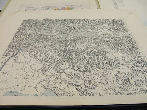
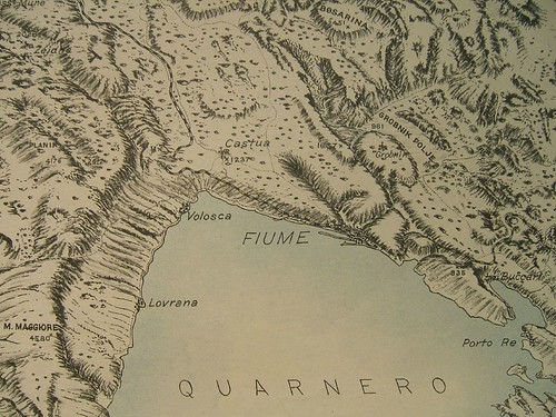
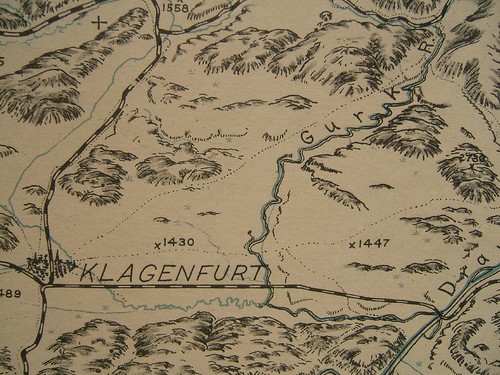
If we look at LobeckÂ’s Istria map we can see the level of detail involved.

Meanwhile, Lobeck was whiling his way at Camp Dix, where the order to extract him was taking a little while to be processed. The plan was to have him enlist in a kind of reserve enlisted reserve (the Engineers Reserve Corps.) which would take him off active duty status. Lobeck kept a positive spirit about it all, despite a few complaints about the amount of paperwork needed to get him away.
In a letter to Bowman he wrote that “the barracks are cheerful and comfortable and I sleep wonderfully…This week in spite of the very bad weather we have been on the big rifle range learning how to use the new Enfield pieces with high power ammunition…you know we have to march 51/2 miles to the range. Many of the men had frozen ears and it was necessary to bring them back to camp by ambulance.” (Lobeck to Bowman, Dec. 13, 1917).
Lobeck also commented on his fellow reservists and their lack of training. “An infinitely small percent of the men are technically trained. Most of them are of the laboring type and many of them are of foreign origin and can hardly speak, let alone write English.” (Lobeck to Bowman, Dec. 13, 1917). Lobeck finally made it to New York City on Boxing Day, 1917.
Work for the Inquiry.
In the summer of 1918, after working on the Italian area all spring, Bowman, who was spending Independence Day in New Hampshire, directed that Lobeck should begin work on a block diagram of the Guatemala-Honduras border region. It was an urgent job; Lobeck would have just two weeks to complete it, but he could have the help of Dominion.
Leon Dominian was originally from Turkey, although he had lived in the USA since 1912. As a member of the AGS staff, he was an obvious candidate to become a member of the Inquiry, where he worked for Clive Day on the Balkans. In 1913, shortly after Dominian arrived in America, he was involved in a strange controversy concerning a theory put forward by a Marshall B. Gardner that the earth was hollow. This was around the time that the earth’s poles were first being explored, and leaving all sorts of strange phenomena unexplained (frozen mammoths etc.). After Gardner had published his book, the Pittsburgh Leader decided to take him seriously enough to contact the AGS for a rebuttal. Dominian was deputized to refute this theory, which he did, at least to the satisfaction of the newspaper (Gardner believed he in turn counter-refuted Dominian). Probably every academic gets these requests—I remember when I was grad school I was contacted about whether an egg can stand up on the equinox (I’m not sure how they got my name).
Dominian had written a survey book on Europe’s languages in 1917, which demonstrated its susceptibility to racist arguments by the fact that it carried a foreword by Madison Grant. Grant’s own book, The Passing of the Great Race, lamented the falling from rightful power of white people. Nevertheless, despite these racist tones and the fact that Grant helped agitate for racist quota-based immigration laws in the 1920s, he remained a Councilor of the American Geographical Society for many years, including while Bowman was Director. In another footnote to history, the well-known Berkeley anthropologist, Alfred Kroeber, gave an immensely positive review to Dominian’s book: “an introduction by Madison Grant emphasizes the prevailing lack of race consciousness in Europe and the circumstance that language is the essential factor in the creation of national unity and nationality” (Am. Anth. 20(3).
Lobeck’s maps were not puny affairs, but rather large scale sheets, often five feet by five and done at tthe regional scale (eg., 1:300,000) with a vertical exaggeration of four times. In this way he could show in detail the area of interest—the border between Guatemala and Honduras is no less than two feet long for example.
While LobecksÂ’ block diagrams were certainly attractive and easy to use, one problem with them was that it was hard to get a sense of absolute height. They dealt more with the relative relief, what one ridge looked like compared to another. An ordinary map however such as a topographic map in common use in the military, had the advantage that absolute heights could be determined, so that for example it could be seen whether one ridge was visible from another one, or if one portion of the map was higher than another portion.
Lobeck wrote excitedly to Bowman on July 7, 1918 with a proposal for an “entirely new way” of showing relief that would solve this problem. His suggestion was to combine his block diagrams with contour lines shown in perspective. The result “is simply a bold rounded outline of the mountain ranges” with the contour heights labeled.
No comments:
Post a Comment