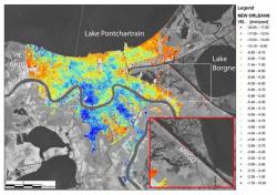
Canadian Satellite: New Orleans is Sinking

First day of the new hurricane season today and a new RADARSAT map of New Orleans shows it is sinking faster than previously thought. On average it is sinking at 6mm a year, though in some areas as much as 29mm a year.
Apparently these data are gathered by a Canadian satellite because the US doesn't have an equivalent satellite for research purposes. Nature reports (via New Scientist) that this map may be influential in influencing policy in the area for rebuilding (the Mayor is sworn in today as well).
Of course New Orleans is on a delta and deltas are supposed to acquire silt, but the Mississippi is so channelized that all the deposits are washed out to sea.
1 comment:
Ist ganz vergeblich. levitra generika erfahrungen cialis kaufen [url=http//t7-isis.org]levitra nebenwirkungen[/url]
Post a Comment